 Introduction: A Storm That Shook the Atlantic
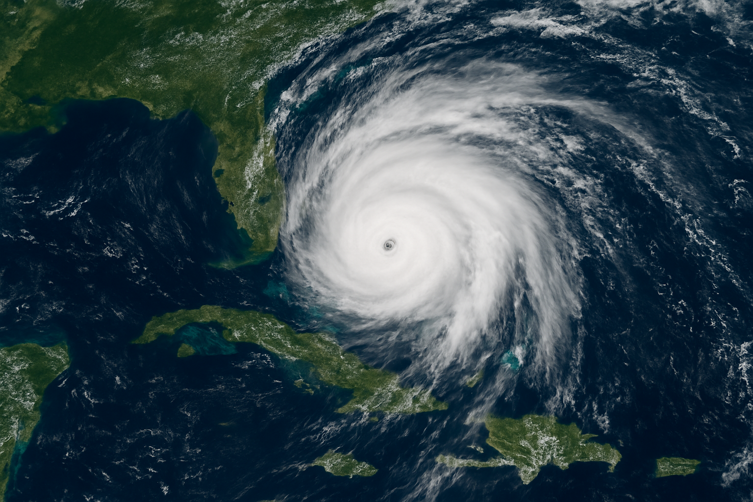
In late August 2025, Hurricane Erin emerged as one of the most powerful storms ever recorded in the Atlantic. At its peak, Erin reached Category 5 status, stretching over 500 miles wide, making it a storm of historic proportions. Though the U.S. mainland has been spared a direct landfall, the hurricane has left its mark with dangerous rip currents, massive waves, and flooding along the East Coast.
This article takes you through Erin’s journey, its impact on communities, the science behind such powerful hurricanes, and the lessons America is learning as climate change continues to intensify storms.
Section 1: Understanding Hurricane Erin’s Journey
1.1 Where Did Erin Begin?
Erin formed off the coast of Africa in mid-August, as warm waters and favorable atmospheric conditions fueled its growth. Within days, it grew from a tropical storm into a monster hurricane. Meteorologists quickly realized Erin would be historic, not because of where it would strike, but because of its size and power.
1.2 The Path Across the Atlantic
Unlike some storms that barrel directly toward the U.S., Erin’s track curved into the Atlantic. However, its outer bands reached the American coastline, lashing Florida, the Carolinas, and up toward New England with strong winds and relentless waves.
1.3 Closest Approach to America
By late August, Erin made its closest pass to the U.S., staying offshore but close enough to cause flooding, road closures, and evacuations. The Outer Banks of North Carolina and parts of New Jersey were especially hit by coastal flooding and 20-foot waves.

Section 2: Impacts on the U.S.
2.1 Dangerous Rip Currents
Even without landfall, rip currents became deadly. Lifeguards reported multiple rescues, and beaches across Florida, Georgia, and the Carolinas raised red flags, warning swimmers to stay out of the water.
2.2 Coastal Flooding and Erosion
Erin’s storm surge chewed away at coastlines. Highway 12 in North Carolina’s Outer Banks was temporarily shut down due to flooding. Small coastal towns struggled to protect homes as seawater rushed in.
2.3 Air and Sea Travel Disruptions
Airports along the East Coast faced delays as winds and heavy rains complicated travel. Cargo ships and cruise lines rerouted to avoid dangerous seas.
2.4 Economic Cost
Though Erin did not hit the mainland directly, the economic losses still mount into billions. Tourism, fisheries, and small businesses depending on summer trade have all taken a hit.

Section 3: The Human Stories Behind the Storm
3.1 Families Forced to Evacuate
Residents in flood-prone areas faced evacuations. Many families left with only essentials, not knowing whether they’d return to dry homes or waterlogged ruins.
3.2 First Responders on the Front Lines
Firefighters, police, and Coast Guard crews worked tirelessly to rescue stranded residents and respond to emergencies.
3.3 Community Resilience
Neighborhoods came together, offering shelter, food, and support. In New Jersey, volunteers set up mobile kitchens, while in North Carolina, churches provided safe spaces for evacuees.

Section 4: The Science of Erin
4.1 Why Was Erin So Big?
Meteorologists point to unusually warm Atlantic waters and a low wind shear environment, perfect ingredients for hurricane growth. Erin’s massive width — over 500 miles across — placed it among the largest 10 Atlantic hurricanes ever recorded.
4.2 Climate Change and Hurricanes
Scientists warn that climate change is making hurricanes stronger, wetter, and more dangerous. Warmer waters fuel storms, while rising sea levels worsen coastal flooding. Erin is another wake-up call about what future storms may look like.

Section 5: How America Prepared
5.1 Forecasting and Early Warnings
The National Hurricane Center (NHC) provided early tracking updates, giving communities time to prepare. Warnings about rip currents and flooding were issued days in advance.
5.2 Emergency Declarations
Governors in several states declared states of emergency, freeing up resources for disaster response.
5.3 Public Awareness Campaigns
Social media and local news played a huge role in urging residents to avoid beaches, prepare emergency kits, and stay safe indoors.

Section 6: Lessons from Hurricane Erin
- Preparation is everything. Communities that evacuated early faced fewer losses.
- Infrastructure needs upgrading. Old seawalls and drainage systems could not handle Erin’s storm surge.
- Awareness saves lives. Public campaigns about rip currents likely prevented higher death tolls.
Section 7: Looking Ahead
7.1 Will Erin Hit Again?
The good news: Erin is moving away from the U.S. and expected to weaken as it heads toward Newfoundland.
7.2 The Atlantic Hurricane Season Outlook
Meteorologists warn that 2025 may still see more storms forming, as conditions remain favorable for hurricane activity.
7.3 What America Must Do Next
- Invest in climate resilience projects.
- Educate the public on hurricane safety.
- Strengthen coastal defenses.
Conclusion: A Storm Without Landfall, But With Lasting Lessons
Hurricane Erin may not have struck the U.S. head-on, but its presence has been felt in every crashing wave, every flooded street, and every evacuated home. Erin stands as a reminder that even without landfall, hurricanes are powerful enough to disrupt lives and economies.
As climate change reshapes weather patterns, America must adapt, prepare, and build stronger communities to withstand the storms of the future.

🌐 Further Reading
Click to expand trusted resources on Hurricane Erin and hurricane safety
- National Hurricane Center (NHC) – Hurricane Erin Advisories
- National Weather Service – Hurricane Safety Tips
- FEMA – Hurricane Preparedness
- NASA Climate – How Climate Change Affects Hurricanes
- NOAA Climate.gov – Hurricanes and Climate Change
- IPCC Reports – Extreme Weather Events
- American Red Cross – Hurricane Relief & Safety
- CDC – Flood Safety and Health Risks
- National Ocean Service – Storm Surge and Coastal Flooding
- Associated Press – Hurricane Erin Coverage
- The Washington Post – Hurricane Erin Impacts
- Axios – East Coast Rip Current Warnings